(A history of Old Windsor,
Berkshire, England)
WHAT'S old about Old Windsor? The question may well be asked
any day of the year by tourists from all over the world when they
notice the name on the road signs during the short trip between
two "musts" for sightseers, Runnymede and Windsor
Castle.
Apart from a glimpse of the river beside the Bells of Ouzeley,
all they can see of the village from their coaches and cars is
the rather nondescript mile of Straight Road, with a cluster of
Victorian cottages and the building known as The Tapestries at
the Wheatsheaf end.
Even if they turn off down a cul de sac to inspect the 13th
century parish church, the only ancient building still standing,
there is nothing to tell them that they are on the site of a town
that was 500 years old before the present town of Windsor was
thought of, and had seen all its history before King John signed
Magna Carta.
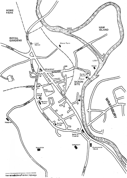 Near the church they will see a house
called The Priory, which dates back to the 17th century, and an
18th century mansion called the Manor, on the site of a medieval
manor house. But of the Saxon and Norman town which at the time
of Domesday Book in 1086 was the third largest in Berkshire,
smaller only than Wallingford and Reading, they will find no
trace.
Near the church they will see a house
called The Priory, which dates back to the 17th century, and an
18th century mansion called the Manor, on the site of a medieval
manor house. But of the Saxon and Norman town which at the time
of Domesday Book in 1086 was the third largest in Berkshire,
smaller only than Wallingford and Reading, they will find no
trace.
It will not be easy for them to believe that even in its
associations with royalty, the settlement which has vanished
beneath the fields bore comparison with the town that took its
name. Yet documentary evidence shows that it was a favourite
residence of Edward the Confessor and the scene of national
assemblies presided over by the first Norman kings. And
archaeological discoveries suggest that it was a seat of kings as
long ago as the 9th century - which takes us back to the time of
Alfred the Great.
Neither here nor anywhere else will the visitor come across
the traditional centre of a Thames-side village, with church,
pubs, shops and cottages grouped around a square or green. The
truth is that Old Windsor is not really a village at all; it is a
ghost town, the "suburbs" of which are all that now
exist.
But if William the Conqueror had built his castle near the old
palace instead of choosing a site just far enough away for a
separate town to grow up around the castle walls, the ghost town
would still have substance. It would in fact be the Windsor which
is the mecca of tourists, and its famous neighbour would not even
be on the map.
The original Windsor was a Saxon settlement established beside
the Thames at what is now called Old Windsor at a date which the
latest archaeological evidence places at least as early as the 7th
century AD.
The name appears in documents of the 10th century onwards,
spelt in dozens of different ways, Domesday Book gives it as
Windesores. Many variants include an "l" - Windlesores
or Windelsora.
Some writers have suggested that the word means the bank (ora)
with winding gear (windles), or more simply the bank of a winding
stream. Others have favoured the idea that the windle part
commemorates a local chief named Waendel (whose territory also
included Windlesham) and that the ore was either a dwelling or a
weir.
The choice of the site was influenced no doubt by its
accessibility by river at a time when what roads existed fell a
long way short of motorway standards. To kings who enjoyed
hunting its proximity to Windsor Forest was undoubtedly a special
attraction.
When did Mr. Waendel's place become a royal demesne?
Excavations in the 1950s on the site of the settlement - known as
Kingsbury - shed some light on this unresolved question.
"It seems extremely probable," wrote the eminent
archaeologist who conducted the dig, "that the tradition of
royal residence at Old Windsor, which becomes explicit in the
reigns of the Confessor and his Norman successors, had begun in
the 9th century."
It is an exciting thought that Alfred, who lived from 849-899,
may have known the place. He was, after all, a Berkshire man. And
if he did, why not some of the Saxon and Danish rulers who
followed him?
In the written records there is, at any rate, abundant proof
that the last Saxon king, Edward the Confessor, spent a lot of
time at the Kingsbury settlement. The first Norman kings, William
the Conqueror and his sons William Rufus and Henry I, held
national assemblies there, and used it as a base for hunting.
If the Conqueror had built his motte-and bailey keep there,
the town would have remained Windsor to the present day and never
reverted to the status of village. But though he called the
fortress Windsor Castle, he chose a more strategically powerful
site two miles away on a chalk cliff at Clewer. And after Henry I
had turned the castle into a royal house, the court deserted the
old town; and New Windsor - as it was still officially known
until 1974 - grew up around the castle.
So old Windsor dropped out of the history books. And within a
comparatively short time all traces of its palace, and indeed of
the whole ancient settlement except the church, disappeared from
sight beneath the fields.
So completely did it disappear that for centuries no one was
quite sure where the palace had stood. Some people favoured the
once-moated enclosure at Bears Rails, just inside the park to the
west of the village, and some inconclusive excavations were
carried out there. Another still-moated site just outside the
park off Clayhall Lane seemed a likely spot to some. As recently
as its 1935 edition, Kelly's Directory included the statement:
"Moat Farm is said to have been the seat of the Saxon kings
and also the place where Earl Godwin died."
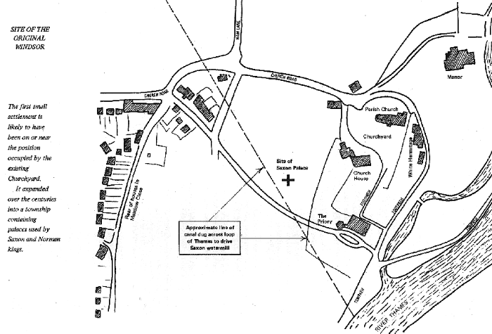
But as Eustace Harwood pointed out in his book "Windsor
Old and New", published in 1929, a site near the church and
river not only fitted in with written records but was the only
place that made sense for the operation of the manor.
The written records include a deed of 1570 which refers to
"the empty parcel of land on which the Manor of Old Windsor
called Kingsburge was once built and the ten acres of arable and
pasture lying in an enclosure between the path leading to the
church of Old Windsor on the north and the royal highway leading
from the south."
Harwood, the son of a former vicar of Old Windsor, printed a
sketch map showing what he believed to be the position of the
Kingsbury settlement in the grounds of the house called the
Priory, south west of the church.
Confirmation of his belief came, quite by chance, some 25
years after his book was published. In September 1951, in a field
long known as Kingsbury, a quantity of pottery, bones, tiles and
burnt material came to light during the cutting of trenches for
pipe-laying. Experts decided that some of the potsherds belonged
to the early Saxon period - from the 7th century AD - and some to
the times of Edward the Confessor and the Norman period.
The Berkshire Archaeological Society promptly sponsored an
exploratory excavation by Brian Hope-Taylor, an authority on
Saxon Britain. Enough was found to warrant a full-scale dig,
which Dr. Hope-Taylor carried out at intervals over the next six
years, on behalf of the Ministry of Works. It covered an area of
20 acres.
As I write, a quarter of a century later, the full official
report of the investigation has still not been published. Dr.
Hope-Taylor told me that masses of material were being stored by
the Department of the Environment, the successors of the Ministry
of Works, and it would take a team of six men many months to
collate it all. Facilities for the work had not yet been made
available.
However the main findings were disclosed in interim reports
published from time to time in the journals of the Berkshire
Archaeological Society and in "Medieval Archaeology." A
selection of the items unearthed, with notes, was displayed in a
permanent exhibition at the Windsor Guildhall.
The dig not only established beyond doubt the site of the
Kingsbury settlement; it also carried the origins of Windsor to a
date considerably earlier than previous evidence had indicated.
The discovery of what might have been the Saxon palace enabled
mapmakers to pinpoint the position of this building with more
confidence. But this palace, if it was a palace, appeared to have
been destroyed by fire at the end of the 9th century, perhaps in
a Viking raid. It could not therefore have been used by Edward
the Confessor and the Norman kings in the 11th century.
The later palace has not been identified, although in addition
to small dwellings the excavations provided evidence of a series
of rectangular halls built and rebuilt on the same spot, and a
suggestion that at least one substantial building was pulled down
early in the 12th century.
Dr. Hope Taylor pointed out that it was not possible to
excavate all possible sites, and that a likely position for an
important central building could have been the spot occupied by
the dwelling house called The Hermitage (now known as The White
Hermitage), adjacent to the church.
The excavations yielded a vast quantity of pottery and other
materials, which when dated by the experts showed that the site
had been occupied continuously for five or six centuries before
the end of the Norman period.
Among the most interesting finds were a prick spur and several
arrow heads, a "poor man's brooch", an iron girdle
hanger (similar to those occurring in pagan Saxon graves), a
small ornamental bronze plate, decorated with interleaved
ornament and gilding (probably part of a dagger pommel) and a
tiny piece of decorated bronze in the shape of a creature rather
like a seahorse, a charming ornament which had perhaps been
inlaid in a wooden article - it was promptly dubbed "The
Kingsbury Beast", and might serve as a symbol of ancient
Windsor.
There were also some fragments of glass (probably late Saxon),
loom weights and spindle whorls, two coins of Henry I, a fretted
bronze brooch, a bronze dress hook, bronze pins, iron keys, an
early Saxon bodkin - used perhaps for thonging leather or mending
fish nets - and some bone combs, made of sawn slats of bone
clamped together with iron rivets.
The most unexpected discovery was a large and sophisticated
watermill made of wood - the only Saxon watermill of its type
ever found. The mill wheels had been driven by the water of a
leat or canal nearly three quarters of a mile long and 20 feet
wide, which had been dug across the loop of the Thames - pre-dating
by a thousand years the "New Cut" made in conjunction
with the Old Windsor lock.
To justify the erection of such a mill about the year 800 - a
date confirmed by the scientific examination of the timbers -
there must have been extensive cultivation of grain crops. Pollen
analysis suggested that its construction was accompanied by local
deforestation.
The artificial channel, which served to isolate the Kingsbury
area - the Thames providing further water protection on the east
side - had been silted up in the late Saxon period. A silver
penny of William I was found in the surface filling.
The building which might have been the Saxon palace stood to
the east of the leat, and after its destruction by fire the
materials of which it had been composed had been thrown into the
canal. It probably had glazed windows - a rare luxury in those
times - and possibly a tiled roof
Most of the buildings on the site were small and comparatively
humble dwellings. Many were sunk below ground level, making side
walls unnecessary, and had roofs of wood and thatch.
Dr. Hope-Taylor's provisional interpretation of the
occupational sequence on the site, printed in "Medieval
Archaeology", suggested that the original Saxon settlement,
initially little more than a farmstead and outbuildings, was on
or near the site of the existing parish churchyard, an area which
it was not possible to excavate, and its nature and duration
remained hypothetical.
Investigation of the available ground nearest to the
churchyard, he said, disclosed what appeared to be a peripheral
zone of secondary development.
The characteristic ceramic form of the second phase was a more
or less bag-shaped cooking pot. A triangular plate of gilt bronze,
of the second half of the 7th century, was found in a position
suggesting that the end of this phase might reasonably be set
between 700 and 750.
Noting that the character of the site changed with the third
phase, he described types of pottery of a more advanced design,
and said the level at which it first appeared might be dated at
the beginning of the 9th century or earlier, since imported
pottery of the first half of the 9th century overlaid it. The
large and sophisticated mill, with three vertical water-wheels
working in parallel, was certainly in existence by the end of
this phase.
In the canal was found abundant domestic rubbish, stratified
above layers of sand and gravel. "The rubbish deposits . . .
were thrown in from the east bank of the leat, and were succeeded
by a thick layer of burned daub and plaster, which in turn was
directly overlaid by a tumble of large blocks of flint, chalk and
sarsen, accompanied by thick tile of Roman appearance . . .
Clearly these deposits represent the life and death of a stone
building to the east of the leat, which was located after a
special search."
Although pointing out that more refined chronology would
emerge from the final analysis of the enormous bulk of the finds,
Dr. Hope-Taylor said that the large mill and its leat must have
been introduced in anticipation of a considerably increased yield
of grain from the new arable areas, and hence to represent
systematic development of the site on a large scale.
"It was surely being transformed into an estate on
manorial lines. The character of the new building at its heart
argued that the whole centred on persons of high rank, and the
higher quality and diversity of the contemporary pottery and
small finds denoted a general enhancement of status and widening
of contacts."
We must be grateful to the archaeologists for throwing so much
light on the importance of (old) Windsor at a period
unilluminated by written records. For the 11th century, at least,
we can turn to documentary evidence.
Domesday Book shows that in 1086 the "Vill"
contained accommodation for nearly 100 families, indicating a
population of perhaps 500. If this seems small, it must be
remembered that in the whole of England in medieval times only a
score of towns had more than 200-300 houses, with 1,000 to 2,000
people. Windsor, as already noted, was the third largest in
Berkshire.
And Domesday Book makes it quite clear that it was a royal
possession. "'Terra Regis. Rex Williemus tenet Windesores in
dominico," the entry begins.
It goes on to say that King Edward held 20 hides, which gives
an indication of the crown land surrounding the palace. The exact
area of a hide varied, but it could have been as much as 120
acres, which would have given the king 2,400 acres.
The arable land in the king's demesne was one carucate (a
measure signifying the area which could be cultivated by one
plough in a year). There were 22 villani (feudal tenants), two
bordarri (cottagers) and one servus (a man paid for working on
the land).
The 'Vill" contained 95 houses besides those on the king's
demesne; and there was the not inconsiderable estate of the
Priest of the Vill, which occupied an area of 1½ hides or
perhaps 150 acres. This became the Rectorial Manor of Old Windsor.
In it was the Rector's official residence, which became Manor
Cottage.
Domesday also mentions a Fishery yielding a rent of 6s.8d and
this was perhaps sited at the Thames weir, where it is known
there was an important fishery called Hornedore. There were 40
acres of meadowland and woodland, with food for 50 hogs.
It should he noted that Domesday, though it refers to Windsor
Castle, the first part of which had just been built, contains no
mention of the town which became the modern Windsor.
There is one pre-Norman reference to Windsor in the Anglo-Saxon
Chronicle, the remarkable series of annals which were maintained
in various English monasteries over several centuries.
Here is G.N. Garmonsway's translation of a passage from the
Laud (Peterborough) Chronicle, which is in the Bodleian Library
at Oxford:
"In this same year (1061) Wulfric, abbot of St. Augustine's,
(Canterbury) passed away on 18th April in Easter week. When word
came to the king (Edward the Confessor) that abbot Wulfric had
passed away, he appointed Aethelsige, a monk from the Old Minster
(Winchester) in his place and complied with the wish of
Archbishop Stigand. He was consecrated Abbot at Windsor on St.
Augustine's Day (26th May)."
Windsor was the scene from time to time of the national
assemblies - known in Saxon times as the Witan and in Norman
times as the Curia Regis - when the king wore his crown. The
Anglo-Saxon Chronicle mentions several such occasions in the
reigns of William Rufus and Henry I.
In 1095, it says, "on Whit Sunday the king (William II)
was at Windsor with all his councillors except the Earl of
Northumbria, because the king would not give him hostages nor
pledge his word that he would be allowed to come and go in safety."
At Christmas the same year, "King William held his court at
Windsor, and William, Bishop of Durham, passed away there on New
Year's Day."
The following Christmas the king was in Normandy but "towards
Easter was to return to this country, for he purposed to hold his
court at Winchester, but he was detained by bad weather until
Easter Eve, so that he landed first at Arundel, and therefore
held his court at Windsor. Thereafter he proceeded into Wales
with a great host…."
Later, dealing with the reign of Henry I, the Chronicle says
that in 1104, "at the Nativity, King Henry held his court at
Windsor; thereafter in the spring he went overseas to Normandy
against his brother, Duke Robert." In 1107 after returning
from Normandy he held his Easter court at Windsor. It was at
Whitsuntide in the year 1110 that "he held his court for the
first time at New Windsor."
Windsor is given in the Chronicle as the scene of King Henry's
courts at Christmas 1113 and at Christmas 1126 (when "David,
the king of Scots, was present, and all the most important men in
England, ecclesiastics and laymen"), but presumably New
Windsor is meant.
The removal of the court to New Windsor spelt the beginning of
the end for the old town. There is archaeological evidence that
some people were still living there until early in the 13th
century, but then, suddenly, it was completely abandoned - why,
no one knows. Perhaps it was devastated during the three-months
siege of Windsor Castle by Louis of France and his English
adherents in 1216.
It is believed that the old Saxon
church - which as part of a royal estate was of much more
than local importance, and which had seen the hallowing of the
new Abbot of St. Augustine's, Canterbury, in 1061 - was destroyed
in this siege.
The church was rebuilt about 1220, and still stands today, the
only remaining link with ancient days. Its joint dedication to St.
Peter and St. Andrew is unique in English ecclesiastical records,
and historians say it probably implies that a new St. Peter's had
been built - before the year 1184 and probably by Edward the
Confessor - on the site of an earlier St. Andrew's.
The original 13th century tower and chancel remain, though the
steeple on the former was added in the middle of the 19th century,
when considerable rebuilding took place. Some of the windows date
back to the 14th century.
If a story retailed by the monk-historian William of
Malmesbury is to be believed, Edward the Confessor performed a
famous miracle at (old) Windsor. It was said that a man named
Wulflin dreamed that the blindness which had afflicted him 17
years before might be cured by divine intercession. He tried 87
churches before reaching Windsor, where the king bathed his eyes
with holy water, prayed to the Virgin - and his sight was
restored.
Also attributed to Windsor by some writers (but with doubtful
authority) are two historical rather than supernatural events -
the death of the powerful Earl Godwin in April 1053 and the
quarrel between Harold and his brother Tostig in 1064 which led
to Tostig's banishment.
As one of his last acts before his death on 5th January 1066,
Edward the Confessor bequeathed the Manor of Windsor, together
with that of Staines, to Westminster Abbey. But it was only
during the short reign of Harold, killed at the Battle of
Hastings on 14th October of the same fateful year, that it was
lost to the crown, for William the Conqueror, after his
coronation in the Abbey on Christmas Day 1066, recovered it in
exchange for Battersea.
In 1184 Henry II gave the churches of both Windsors as a joint
parish to the Abbey of Waltham Holy Cross in Essex. As a result
the Abbot of Waltham became Rector of Old Windsor and succeeded
to the privileges the church had long enjoyed. He was also rector
of other parishes and tended to delegate his ministerial duties
to itinerant priests. This practice gave considerable
dissatisfaction locally, and early in the 13th century resident
ministers were appointed, the first at Old Windsor being Richard
Turk.
But the Abbots of Waltham continued to be the actual Rectors
until the suppression of the monastery in 1520, whereupon the
Rectorial Manor and the great tithes from it passed to Henry VIII,
who also acquired the house called Walton's (later named Woodside)
and other properties.
In 1282 Edward I leased the town of Old Windsor to John of
London at an annual rent of £23. Edward II gave it and several
neighbouring manors to Oliver of Bordeaux, but in 1359 Edward III
regained it for the Crown, giving Oliver's heir other land in
exchange.
The Inclosure Award map of 1817, in the Public Records Office
at Reading, shows that after another 500 years nearly all the
riverside area of Old Windsor, including the grounds of the
Priory (the site of the Kingsbury settlement), was still Crown
land, leased out to tenants. Even today, much of the parish
belongs to the Crown.
Housing development tended to take place on what had formerly
been common land, away from the Crown land by the river. This is
the main reason why the parish church, still in the position it
occupied in the Middle Ages and earlier, became separated from
the bulk of the community it served.
The modern village grew up on a curving strip of waste land
known as the Moor, which stretched more or less along the present
line of Burfield Road and St. Luke's Road. The last unenclosed
part of the Moor became Old Windsor Green, and this dwindled to
the patch of grass in front of the Fox and Castle public house.
The southern end of the Moor was Ley End, the flat riverside
area around the Bells of Ouseley being the Ley - a variant of Lea,
or meadow. There were many leys along the Thames and the
unromantic but most likely reason for this one getting the name
Ouseley is that the land was low-lying, subject to flooding and
often muddy, so that the river users dubbed it the Ooze-ley.
Ouseley Road, Old Windsor, and Ouseley Road, Wraysbury are
opposite each other on opposite sides of the river, which may at
one time have been fordable at this point.
The northern end of the Moor divided into two parts, one along
the present line of Albany Road and the other stretching across
to Manor Farm and the weir on the Thames.
The Moor, still of considerable extent at the beginning of the
17th century, was gradually enclosed, piece by piece. Between it
and the royal land along the river were four large Common Fields
used by the village community - Hamfield to the north, within the
bend of the river, Eldersworth field between the two northern
arms of the moor, Northfield at the northern end of what became
Straight Road, and Burghfield to the south of it extending to Ley
End. These remained almost intact until early in the l9th century,
when what land was left was allocated and fenced under the
authority of the Enclosure Acts.
The Old Windsor Inclosure Commission held its first meeting at
the Bells of Ouseley in 1813, and met altogether on 90 occasions
over the next five or six years. Parts of Windsor Forest were
enclosed under an Act of 1813, which granted the King nine-thirty-seconds
of all the waste (uncultivated land) in satisfaction for his
forest rights and another two thirty-seconds in parishes where he
was Lord of the Manor.
It was on the instructions of the Inclosure Commission that
Straight Road and most of Church Road were created in 1816 and
the old "Kings Highways" went out of use.
Mr. Harwood in "Windsor Old and New" said that these
King's Highways served the medieval Kingsbury settlement. One of
them ran along its western boundary, and this road was in use as
part of the main road from Staines to Datchet and New Windsor
until Straight Road was cut. Its "ghost" is still
visible, for much of its line can be traced today as a tree-lined
ditch running behind the back gardens of houses in Meadow Way and,
to the north of Church Road, crossing the fields to the west of
Manor Farm. To the south it joined the line of Straight Road near
the southern junction of Meadow Way.
Another King's Highway, along the north side of the Kingsbury
enclosure, connected it to the river at the junction of the
Thames and the Manor Cottage moat, part of which still exists as
a backwater used for mooring boats.
Originally, after following the line of an existing section of
Church Road (from the Ham Lane junction), the old road turned
sharply south-eastwards across the churchyard, from the site of
the present lychgate. In the year 1225 it was diverted round the
north of the church. The then Rector had obtained permission from
Henry III to enclose the churchyard on condition that he built
the "by-pass." Now the road is only open for vehicles
as far as the White Hermitage, adjacent to the church, but as a
footpath it still connects with the river towpath.
From the western side of the Kingsbury enclosure, there was
another royal road running west to the Windsor Forest, now the
Great Park. No doubt it was used for hunting trips by William
Rufus, a king destined to die in another forest. The line of this
followed more or less the east-west part of the present Meadow
Way, and crossed Straight Road and St. Luke's Road. A section of
it still exists as what used to be called Miller Lane, and is now
labelled "Crown Estate, Private," on the west side of
St. Luke's Road, opposite the recreation ground. It continues
across the fields as a depression lined with trees, like the one
in the Church Road area.
Albert Road is even newer than Straight Road. It was made in
1851, when the road through the Royal Gardens and Frogmore in the
Home Park was closed to the public.
While New Windsor grew steadily into a large built-up area,
Old Windsor stood still for centuries, populated mainly by large
land-owners and farmers, and by their employees and the
tradespeople who served them.
Yet it steadfastly retained its separate identity and, with
the Home Park as a buffer between it and the castle, never became
a suburb of the new town. It was not even part of the Royal
Borough of New Windsor, but with Sunningdale and Sunninghill,
formed the Rural District of Windsor, being the largest in area
of the three constituent parishes.
The Rural District Council, created in 1894, was the local
authority until the reorganisation which took effect on 1st April
1974. Now it is part of the Royal Borough of Windsor and
Maidenhead, which also swallowed up the Royal Borough of New
Windsor, the Borough of Maidenhead, the urban district of Eton,
the rural district of Cookham and the parishes of Datchet, Horton
and Wraysbury. But the Old Windsor Parish Council survived to
represent, within the limits of its largely advisory powers, the
interests of the village.
Of the large estates which still exist in some form, the
oldest are the Manor (near the church), Woodside (at Crimp Hill
to the south-west of the village), Beaumont (at the junction of
Burfield Road and Priest Hill), and Runnymede House, to the east
of Priest Hill.
In the 18th and 19th centuries, when Old Windsor was a
fashionable residential area, some more big houses, such as The Grange, Burfield Lodge, The
Elms and Pelling Place, were built, together with a sprinkling of
cottages, but the total number of dwellings remained small.
The Inclosure Award map of 1817 records the tenants of the
Crown land along the river at this time. The Manor was leased to
Mr. H. Powney Isherwood, the Manor Farm area to Mr. John Sturges
and the northern part of what is now Ham Island to Queen's
College, who also owned land between Straight Road (then called
the Windsor Road) and Burfield Road (then called the Windsor and
Maidenhead Road).
Viscount Ashbrook owned the Beaumont Estate, which ran right
down the river, Mrs Bonnell the Pelling estate, west of Burfield
Road, and Mary Carbonell the land on the west side of Straight
Road, near the present Ouseley Road.
A local directory for 1898 lists only 30 houses occupied by
what were called "Gentry and Private Residents." They
include Lt. Col. R. Follett and Lady Julia Follett at Woodside,
the Hon. Lady Murray at the Grange, Lt. Col. the Hon. W.H.P.
Carrington at Burfield Lodge, the Hon. R. Butler D.L. at Ouseley
Lodge, Mr. T. Eyre at Runnymede House, Mrs Henage at The Priory,
Mr. M. Davidson at The Tapestries, Mrs. Irving (nee Bonnell) at
Pelling Place, and Mr. H.W. Birch at The Grove.
By 1901 Lord and Lady Dunboyne (he was chairman of the parish
council) were at Ouseley Lodge, and Mr. F. Ricardo, also a parish
councillor, at the Friary. Mr. D. Urquhart lived at Manor Lodge,
Mr. Maclaren at the Hermitage, Capt. Fritz Ponsonby at Cell Farm
and Col. Stevens at The Elms. Beaumont Lodge, of course, was a
Roman Catholic college.
There were not many shops around the turn of the century, but
the community was well supplied with pubs - the Bells of Ouseley
(landlord W. Haines, later H. Blake), the Lord Nelson (F. Haines),
the Fox and Castle (R.M. Canter), the Wheatsheaf (W.W. Vasper),
the Fox and Punchbowl (H. French), the Jolly Gardeners (H.
Reddick, also a grocer), The Oxford Blue (G. Shackle) and the
Union Inn (W. Young). All these still survive except the Fox and
Punchbowl, which was near Adelaide Cottages in Burfield Road.
Tyle Place, the attractive modern estate built for royal
estate employees at William Ellis Close, off Albany Road,
preserves the name of an ancient Old Windsor family and an
ancient local industry.
Tiles and bricks were made in the area for many years,
particularly between the 13th and the 16th centuries. The
industry indeed probably dated back to Roman times, In 1865 two
Roman tombs of the 3rd century AD, known as tile tombs, and
containing pottery, were discovered at Tyle Place Farm (one of
them can still be seen in the British museum), and it is thought
likely that the tiles were made locally.
Still-existing names like Clayhall Lane, recent ones like Kiln
Farm and ancient ones like Tilebedburn (a little stream, now
piped underground, running into the Thames near the Surrey
boundary) testify to the prevalence of the industry. In the 17th
century both bricks and tiles were being made at Old Windsor Wood,
to the west of Crimp Hill, and there are still signs of the
former clay pits just inside the park. Peters Hill is a
corruption of Pitters Hill.
There was in medieval times a Manor of Tile, which gave its
name to prominent local family, spelt variously as Tile, Tyle or
Tyghele. In the days of one Gilbert de Tile, the land was taken
into the king's hands as part of the Manor of Old Windsor. A
possible site for the original manor house was within the moated
area which was later occupied by Tyle Place Farm. The remains of
the quadrilateral moat can be seen on Crown land in the fields
off Clayhall Lane.
The names of the big houses in Old Windsor tend to confuse
rather than assist anyone trying to discover their history. The
Priory, for instance, was never a priory and the Friary was never
a friary. No hermit is likely to have lived at the Hermitage.
Beaumont used to be called Remenham, or Remnans. Woodside used
to be called Waltons. Runnymede House used to be called Lodder,
after a lake which once existed in the Berks-Surrey boundary.
Newton Lodge used to be The Grange.
The Priory, standing on the site of the old Saxon town, would
have had a fair claim to the name of Kingsbury, but it was once
called Grove House, not to be confused with the Grove House in
Straight Road, near Ouseley Road. The Friary was built on the
site of an earlier house called Princess
Elizabeth's Cottage, previously called the Garden House.
The Mansion known as the MANOR, now an old people's home but
owned over the years by many noted people, including an Indian
Maharajah, stands between the parish church and the river on land
which at the time of Domesday belonged to the Priest of the Vill,
and became the Rectorial Manor of Old Windsor.
Prominent local families, including the Michels, the Powneys
and the Isherwoods, occupied the Manor house over the centuries.
Just before the old house was pulled down in I860 Mr. Henry
Isherwood was living there.
The present building, which took the name Manor Cottage, was
built on the site by Colonel George Howard-Vyse, a gentleman
Usher to Queen Victoria. Around 1890, Sir John Harrington, Bart,
was the occupier. The Maharajah of Rajpipla - who won the Derby
with Windsor Lad acquired it in the late 1920's and was there for
about 30 years.
In the 1950's Middlesex County Council took it over as an old
people's home, the administration of which was later transferred
to Surrey County Council. Excavations during the alterations
revealed parts of a skeleton, believed to have come from a Saxon
graveyard on the site.
BEAUMONT, the large estate at the
junction of Priest Hall and Burfield Road, accommodated a Roman
Catholic college for more than a century, and is now used as a
computer training centre.
It was once called Remenham, after Hugo de Remenham, who held
the land at the end of the 14th century. After a period in the
ownership of the Tyle family, the estate was successively
occupied in the 17th century by John Morley, Francis Kibblewhite,
William Christmas and Henry Frederick Thynne, who was clerk to
the Privy Council in the reign if Charles II.
In 1714 it was inherited by Thomas Thynne, who was created
Lord Weymouth, and 30 years later it was bought by Sophia Duchess
of Kent. At that time the grounds extended right down to the
river. In 1751 the Duke of Roxburghe purchased it for his eldest
son, the Marquis of Beaumont (then a boy at Eton) and renamed it
Beaumont.
In 1786 Beaumont Lodge acquired its most celebrated tenant-
Warren Hastings, the first Governor-General of India. "I
have bought a very pleasant little estate of 91 acres at Old
Windsor called Beaumont Lodge," he wrote to a friend. It
cost him £12,000.
His trial in the House of Lords on charges of cruelty and
corruption in India had started six months before. It was to last
seven years, and end in his acquittal. He only lived at Beaumont
for three years however. In 1789 he sold the estate, which
included the Bells of Ouseley public house and the adjoining
Duncalves Close to Henry Griffith, an Anglo-Indian. Griffith
pulled down the Beaumont Lodge building, which had stood for
about 100 years, and engaged an architect named Henry Emlyn to
erect the house which still stands, and which the boys of
Beaumont College knew as The Old House.
In 1805 Beaumont was bought for nearly £14,000 by Viscount
Ashbrook, who was a friend of George IV. He built Ouseley Lodge
on Duncalves Close for his son-in-law Captain Every. After his
death in 1847 his widow disposed of the Bells of Ouseley but
lived at Beaumont until 1854, when she sold it to the Society of
Jesus.
For seven years it housed Jesuit novices of the English
province of the Society of Jesus and then, in 1861, it was turned
into a Catholic boarding school with the title of St. Stanislaus
College, Beaumont.
A history of the first fifty years of this school, issued in
1911, recalls that its occupation by the Jesuits in 1954 was
carried out almost in secrecy, due to the strong feelings against
Catholics at that time - "a universal and exaggerated state
of frenzy or mania" connected with the appointment of the
Cardinal Archbishop of Westminster. These feelings, it was feared,
might be further provoked by a Jesuit novitiate so close to
"the palings of Windsor Castle." That the antagonism
did not last many years was proved, as the school history points
out, by the fact that Queen Victoria herself visited the school
on three occasions.
The college in fact flourished at Beaumont until 1967, when
partly for financial reasons, it was amalgamated with Stoneyhurst.
The following year the mansion was taken over by International
Computers Ltd as a computer training and conference centre.
WOODSIDE, standing in
extensive grounds on Crimp Hill, to the south-west of the village,
has a similarly long history, dating back to Norman times.
At the end of the 14th century the estate belonged to Thomas
Walton, who was valet to King Richard III, and it was in fact
called Waltons until the middle of the 18th century, when it was
renamed by its owner, Hugh Hammersley.
The present mansion, a late 17th century restoration, was once
the home of members of the Michel family, and in the 1820's was
occupied by the then MP for Windsor, Mr. John Rowbottom. In the
middle of the 19th century it belonged to Mr. William Devas.
Colonel (then Captain) R.W.W. Follett was the owner throughout
the last quarter of the 19th century, and Lady Julia A. Follett
was still there in the 1930's.
In the autumn of 1975 the estate was acquired by the pop star
Elton John at a price reported to be in the region of £400,000.
It was described as a Queen Anne period house, standing in 37
acres, with six bedrooms, six bathrooms, two tennis courts, a
squash court, a heated swimming pool, stabling and a Georgian
orangery.
It may be a sign of the times that it then became apparently
the most security-conscious estate in the area, elaborately
fenced and patrolled by guard dogs.
THE PRIORY, to the south of the parish church, is the oldest
building on the site of the Saxon and Norman settlement. apart
from the church itself.
About the year 1700, it appears to have been a smallish house,
which by tradition had been an Inn. but in the first half of the
18th century it was turned into a substantial mansion. About 1730
the lease was acquired by Richard Bateman, son of a Lord Mayor of
London, Sir James Bateman. He engaged Thomas Robins to make
improvements to the house and grounds, with the result that
"Bateman's" became something of a showpiece, while
Bateman himself became in effect the local squire.
The estate was auctioned in 1775 and bought by Lord
Cholmondeley. In 1812 Princess Elizabeth, daughter of George III,
took it over and occupied the Garden House to the south (on the
site of the present Friary), which Bateman had converted from a
cowshed.
The Priory has had a number of owners over the past century,
including members of the Romaine family between the 1870's and
the 1930's. In 1972 the house, with 33 acres, was acquired by Mr.
Michael Shanly, head of a firm of builders and developers, and he
moved in with his wife and family. He built handsome new entrance
gates in Church Road, and has been carefully restoring the house.
It has a number of elegant rooms, including a drawing room
decorated in Empire style, a morning room in Jacobean style and a
bedroom in the style of Robert Adam. Some of the windows contain
rare 17th century painted glass of Dutch/German and French origin.
There is an octagonal chapel, with Norman arch doorways.
NEWTON COURT, the large building in Burfield Road which
accommodates the King Edward VII Hospital nurses training school,
was a mansion called The Grange, and was the home at the
beginning of this century of the Hon. Lady Murray.
Built early in the 18th century, it was originally known as
the White House and then as Old Windsor Lodge. One of its
earliest owners was Sir Charles Hanbury Williams.
In the 1930's it became the Newton Court Hotel. At the
beginning of the war it was used for a time by the London and
Manchester Assurance Company.
BURFIELD LODGE, built about 1800, was the home of Mr. H.T.
Curtis in the middle of the 19th century and of Lt. Col. the Hon.
W.H.P. Carrington JP, at the end of the century.
In the 1920's its owner was Mr. A. PiIkington Shaw, a Deputy
Lieutenant of the County. Mr. J. A. PiIkington Shaw, the
physician and surgeon, was there until the time of the last war.
The 30 acres of grounds, laid out at great expense in the 1920's
were largely sold for development, and the recently-built
Ashbrook Road estate and Harwood Gardens now cover the site.
The house is still a private residence but is divided into
east and west wings.
THE FRIARY, a typical mid-Victorian mansion, was built in 1873
by Mr. Francis Ricardo, who was still living there at the end of
the century. Before the second world war it was turned into flats,
and its grounds, which formed part of the Priory estate in
Bateman's day, were developed with a riverside estate of some 30
houses, also called The Friary.
Mr. Ricardo's house replaced one on the same site which was
called Princess Elizabeth's Cottage
because from about 1812 it belonged to Princess Elizabeth,
daughter of George III.
As noted above, it had been converted by the enterprising Mr.
Bateman from a cowshed into The Garden House.
Mr. Ricardo, a Justice of the Peace and member of the Parish
Council, also owned land on the west side of Straight Road.
THE HERMITAGE, which adjoins the churchyard and beneath which
there possibly lie remains of a palace used by Norman Kings, was
another Richard Bateman enterprise. He built it about 1740.
It was occupied in the 1850's by Mr. R.W.G. Isherwood, in the
1870's by Mr. J.P. Walls, and at the end of the century by Mr.
Maclaren.
The White Hermitage, as the house is now called was owned in
the 1920's by Mr. F.W. Black and in the 1930's by Capt. T.A.
Fairhurst.
OUSELEY LODGE, in Ouseley Road, behind the Bells of Ouseley,
was built by Lord Ashbrook, owner of Beaumont Lodge, for his son-in-law
and daughter, Capt. and Mrs. Every, early in the 19th century.
Occupiers in the second half of that century included the Rev.
W.Rooper and the Hon. R.F.J. Butler. At the beginning of the
present century Lord and Lady Dunboyne lived there, in the 1920's
County Councillor Sir George Peters and later Captain Peters.
It is now divided into flats and a small estate was built in
the grounds in 1975.
TAPESTRIES, the large
mock-Tudor building at the northern end of Straight Road, was
erected in the 19th century as a centre for the revival of the
ancient art of tapestry weaving in England.
Tapestry Hall was used for many village functions from 1895,
when Mr. F. Ricardo made it available. It is now divided into
flats.
The new Pelling Hill estate on the west of Burfield Road is
built on part of the grounds of PELLING PLACE, a house erected in
the second half of the 18th century by Francis Pigot MP and named
after his uncle, Canon John Pelling.
It was owned in the middle of the 19th century by James
Bonnell and later by Miss Elizabeth Bonnell. The estate then
comprised not only of Pelling Place, with the Home Meadow and
Paddock, measuring about 16 acres, but also 14 ½ acres on the
other side of Burfield Road, including cottages and the field
called The Leas, or Lea Meadow later filled by the houses in
Ouseley Road and part of Straight Road, and more recently by the
Tudor Lane development.
Title deeds of which copies have passed to existing tenants
not only demonstrate how these old estates became broken up but
hint at a story dramatic enough to form the plot of a novel.
An indenture dated 1871 shows that Elizabeth Bonnell proposed
to marry Mr. W.J. Irving of Penrith, and a legal settlement was
drawn up under which, with the concurrence of her husband-to-be,
she granted her property to a Mr. Thomas Wright of Carlisle,
subject to various safeguards, one of which was that she should
use it herself until her marriage.
The next document, dated 1878, refers to an order of the Court
of Lunacy, under which Thomas Wright is deemed to be of unsound
mind, and trustees are appointed in his place.
Then comes an even more tragic note.. On or about August 1st
1884 Mr. W.J. Irving and all his children died at sea - in what
circumstances it is not stated.
So in 1888 we find Elizabeth Irving getting legal sanction for
all the property to revert to her control. Under her will, dated
1906, she devised the Pelling Place estate to her sister Mrs.
Mary Jane Hudson. Elizabeth Irving died in 1920 and her sister in
1922, and the land passed to her sister's children, who disposed
of nearly 32 acres in 1923 for £4000.
In 1933 the land on which Nos. 6-10 Ouseley Road were built in
that year was sold to the developer for £675.
Old Windsor's best-known hostelry is the BELLS OF OUZELEY spelt nowadays with a
"z". Its riverside position, only half a mile from
Runnymede, on the route of Windsor tourists and Ascot racegoers,
keep its bar and restaurant busy, and fills its large car park,
all the year round.
In its present form the hotel dates from the "roadhouse"
era of 1936, when the earlier, country-pub-type Bells was pulled
down and rebuilt. Old prints show a three-storey building, with
steps up to the entrance. The towpath in front of it was subject
to flooding at times, and vehicles passed to the rear of the pub,
via Burfield Road and Ouseley Road.
Towards the end of the second world war, in 1944, the inn was
unlucky enough to be hit by a flying bomb fired by the Germans
from across the Channel. (It was not, as commonly stated, the
first VI, which fell in June near Gravesend, or the first V2,
which fell in September at Chiswick). The bomb blew off the end
of the dining room, wrecked the rooms above it, and extensively
damaged the whole building. Two people were killed.
Although the blast blew out all the doors and windows, the
five "bells" made of red Bristol glass which were
resting on top of a cupboard in the bar were miraculously
unbroken, and they can still be seen in the bar today.
These glass bells commemorate the event which, according to
tradition, gave the pub its name. The story is that at the time
of the dissolution of the monasteries in the 16th century, monks
from Oxford made a raft to carry their monastery bells down the
river to safety, but at Old Windsor the shallowness of the river
prevented further progress, so - as illustrated in the modern
innsign - they buried the bells in the "ooze" of
Ouseley
There has been an inn on the site for centuries - perhaps even
before the dissolution of the monasteries and the first use of
the word "Ooze-ley." Many riverside hostelries were
established in the days when the Thames was a safer and more
comfortable highway than the roads.
That the Bells has enjoyed its reputation for hospitality for
something like 250 years, at least, is shown by the following
paragraph from "A Voyage up the Thames," published in
1738:
"We had now, by a slow-advancing pace, got within sight
of a place called the Bells of Oozeley, where our Mariners
advised us to dine, and we found it well worthy our Company...
during the whole voyage I do not remember any part of the river
so delightful."
Up to the middle of the 19th century the Bells of Ouseley was
part of the Beaumont estate, and was leased out to innkeepers. It
was some time after the death of Lord Ashbrook (1847), that the
freehold was acquired by Simmons brewery. It is now a Courage
house. NOTE 1.
Landlords over the past century have included John K. Heywood
in the 1850s, John Hull in the 1870s, W. Haines and H. Blake
around the turn of the century, C.A.W. Burgess in the 1920s and D.
Matheson in the l930s. Proprietor since 1962 has been Mr. Bill
Wing.
The oldest unchanged inn in the village is the picturesque FOX AND CASTLE in Burfield
Road. It is reputed to be 400-500 years old, and there is a
record that Joseph Lever was landlord in 1741, when it was called
Ye Fox. Early in this century it also housed the village bakery.
The space in front of it is the last remaining part of Old
Windsor Green. There was a pond there which was filled in in the
1920s.
Another pub with a long history is the WHEATSHEAF in Straight Road, but
it was rebuilt on a new site in the 1930s. The old pub stood
about 300 yards to the north of the present one, on what is now a
traffic roundabout, and it jutted out into the highway, creating
a traffic hazard. It was rebuilt on a cornfield known as The
Triangle and it now shares a concrete forecourt with a petrol
station. Behind it, fronting St. Luke's Road, a parade of shops
completed the development of the field. NOTE
2.
The LORD NELSON in Datchet Road (once known as Gallows Lane)
is a Victorian pub which is still part of the Crown Estates. When
the manufacture of tapestries began in the village in 1876 the
wool was dyed in vats in an out-house behind the pub. The annual
beer rolling race between the Nelson and the Bells of Ouseley at
the other end of the village is a custom still observed on Boxing
Day.
Other pubs that have quenched the thirsts of the locals all
through the century are JOLLY GARDENERS in St. Luke's Road and
the UNION INN in Crimp Hill. In December 1979 two former Chelsea
footballers, Peter Osgood and Ian Hutchinson, took over the
licence of the Union from Mr. and Mrs. John Hare, who had been
there for 26 years.
The junction of Crimp Hill and Burfield Road was once known as
Stocks Corner, as the stocks stood there until Victorian times.
That end of Crimp Hill used to be known at different times as
School Road, as the village
school was there, and as Union Road, as it led to the Union
Workhouse, which became the Old Windsor Hospital, taken over by
the Windsor Hospital Management Committee in 1948 as a geriatric
unit. NOTE 3.
Only for a few hundred yards in the vicinity of the Bells of
Ouseley is the Thames visible to those who pass through the
village by road, but the history of Old Windsor is closely bound
up with the river, which forms its eastern boundary.
As previously noted, the choice of the site for habitation in
Saxon days was probably determined by its accessibility by water.
The landing area for the Kingsbury site was a short distance
downstream from the present Old Windsor Lock, where there is a
backwater used for moorings. It is still a remote spot, reachable
only on foot from Church Road by a narrow footpath, or from the
Ouseley area by a longish walk along the towpath. Perhaps the
scene is not all that much changed since royal barges brought
Edward the Confessor or William the Conqueror for national
assemblies.
The course of the river seems to have varied little since
medieval days, except of course for the "New Cut" made
in 1821-22, which is now the navigation channel, by-passing a
large loop of the stream and turning Ham Fields into Ham Island.
Much of this island is taken up with sewage works and restricted
as a bird sanctuary, but the southern part is residential.
Old Windsor Lock, and the south-eastern end of the cut, was
opened to traffic in September 1822. The present weir, at the
north-eastern end of the cut, was not built until October 1838,
but it replaced an earlier weir, situated just downstream from
Newmans Bucks, a former eel fishery, which was situated between
the islands (only one of which now remains) at the head of the
present weir. Old pile stumps have been removed from the river
bed hereabouts and it may be that a weir has existed at the spot
since the 13th century.
For many years - perhaps centuries - until the 1950s, two ferries provided links
between Berks and Bucks at Old Windsor. One was operated from the
Bells of Ouseley and a drawing of the
ferryboat in Victorian days appears here. You rang a big ship's
bell to summon it from the Wraysbury side. The upper ferry was
operated from Cooke's boatyard in Wraysbury to a point between
Old Windsor Church and the Priory. Old residents remember that
the electric factory ferry cost sixpence.
On the river side of Straight Road, opposite Ouseley Road,
stands an old signpost, and the arm giving the distance to
Staines and Egham adds the proviso "Except at high water."
There is of course no tide on this part of the river and the
"high water" presumably referred to the susceptibility
of the road through Runnymede to flooding. Traffic at one time
used to pass behind the Bells of Ouseley, but horses towing
barges of course had to stick to the towpath and an official
report towards the end of the 18th century recommended raising
the road level at this point. A new road between the Bells and
the river was opened in May 1929, and the first to drive a car
along it was the then MP for Windsor, Mr. A.A. Somerville.
A flood bank to protect Old Windsor was made in 1823 with
money from public subscriptions, but in 1894 it burst and the
village was flooded. In the 1947 flood the bank was only just
saved after day and night repairs, using German POWs.
Barges used to have to pay tolls at "pay gates" -
equivalent of the highway turnpike. There was one of these near
the present Crevald's Boathouse (NOTE 4),
and a house at that spot - it was pulled down early in this
century - was called Watergate Cottage.
A remarkable DUEL - perhaps the last ever fought in England -
took place at Old Windsor on October 14th 1852, in a part of the
Beaumont estate off Priest Hill. The protagonists were both
Frenchmen, and both had fought several duels before. They were a
formal naval captain named Cournet and a civil engineer named
Bartlemey. Accompanied by their seconds, they took up their
positions in a field behind a hedge, and aimed their pistols.
Cournet fired first, and missed. This allowed Bartlemey to take
his time about shooting, but when he did so the gun misfired. He
pulled the trigger again and the same thing happened. Instead of
taking advantage of this, Cournet offered his own pistol to his
opponent, who accepted it and fired. Cournet fell wounded, while
Bartlemey and his two companions made off. The unfortunate
Cournet was taken to the Barley Mow inn at Englefield Green,
where he died of his wounds. Meanwhile the landlord of the Bells
of Ouseley, Mr. Heywood, had got to hear of the incident. He rode
at full gallop to Windsor, where the police dispatched a telegram
to Waterloo: "Detain three foreigners travelling from
Datchet." Arrested by the Metropolitan Police, Bartlemey was
charged with murder but got off with a short sentence for
manslaughter. There was a suggestion that one of his seconds had
tampered with the gun he used in the duel, to prevent it from
firing. If so the manoeuvre was foiled by the excessive chivalry
of his opponent.
A century ago the POPULATION of the parish of Old Windsor -
which extends far beyond the village and includes most of the
Great Park - was only about 1,500, an increase of not much more
than a thousand in the eight centuries since William the
Conqueror. In 1900 it was about 1,750. The latest official figure
is 5,210 of whom 4,805 live in the village itself. Of these 1,400
have come in the last 20 years.
In 1930 there were only about 475 houses - a figure which had
risen to some 675 by 1940, 775 by 1950, 1,600 by 1960 and nearly
1,900 by 1970.
In the early years of this century, the main concentration of
dwellings was in the St. Luke's Road and Albany Road area.
Between the wars a number of houses were built in Straight Road,
Ouseley Road, The Friary and elsewhere, with council houses in
Church Road, but the principal expansion has come since the last
war.
The big private enterprise Ashbrook Road and Meadow Way
estates, built by Taylor Woodrow, and a number of smaller
developments, together with local authority housing at Kingsbury
Drive, Queens Close, St. Peters Close and St. Andrews Close, with
old people's dwellings at Pollard Close, have filled in much of
the open land on both sides of Straight Road.
To meet the influx of population, new schools have been built,
more shops have opened and other amenities have been provided,
such as the Memorial Hall, opened in 1961.
Encompassed on one side by the Thames, and on others by
Windsor Park and Runnymede - permanent open spaces of great
natural beauty - Old Windsor is unlikely to grow much bigger, but
it is nearer now to township status than at any other time since
the days of its glory, a thousand years ago.
Photographs
of Old Windsor from 50 and 100 years ago.